 |
Golden CO (SPX) Apr 18, 2011 Exactly who uses Landsat satellite imagery and what value do they derive from the information? In the first study of its kind, U.S. Geological Survey investigators surveyed a broad cross section of Landsat users to answer such questions. The short answer is that an expansive range of customers - academics to foresters and urban planners to agricultural managers - use Landsat satellite imagery in a wide variety of applications. "Landsat imagery is readily seen as a scientifically unbiased, policy neutral source of information," said USGS Director Marcia McNutt. "When people from varied professional backgrounds and with different technical skills can all examine and understand the same image, the decision making process becomes more objective and more inclusive. The significance of this study is in accurately identifying who uses Landsat and why." More than 2500 users of satellite imagery, including almost 1400 current users of Landsat imagery, in private, academic, government, and nonprofit sectors participated in the 2009-2010 survey. Respondents were surveyed about their use of satellite imagery, including Landsat, and what the impact would be without access to Landsat imagery. Each of 37 different application areas investigated - from agriculture and environmental management to education and disaster response - were primary uses for some respondents. More than 91 percent of respondents who currently used Landsat imagery used it to answer questions or solve problems, while 57 percent reported using the imagery as a basis for decisions. More than 80 percent said the imagery is somewhat or very important to their work. Remotely sensed Landsat images are not just pictures, but contain many layers of data collected at different points along the visible and invisible light spectrum. Among a multitude of possible applications, the data can be interpreted to reveal what types of vegetation are present, the status of soil and vegetation, or how a natural disaster has impacted an area. Landsat provides valuable data for land use research and advances the Department of the Interior's important role in land remote sensing under the President's National Space Policy. Landsat images are unique in that they provide complete global coverage, they are available for free, and they span nearly 40 years of continuous earth observation. No other satellite imagery has that combination of attributes. The study, "The Users, Uses, and Value of Landsat and Other Moderate-Resolution Satellite Imagery in the United States-Executive Report," is available here.
Share This Article With Planet Earth
Related Links USGS Earth Observation News - Suppiliers, Technology and Application
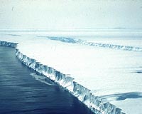 Pulling Back The Sheets
Moffett Field CA (SPX) Apr 13, 2011 Melting ice sheets from Greenland and Antarctica has long been tied to rising sea levels. But these two sources are outpacing all others - including mountain glaciers and ice caps - to become the dominant feature in raising the seas, according to a new study slated for publication this month in the journal Geophysical Research Letters. Part of the reason for the significance of these polar ... read more |
|
| The content herein, unless otherwise known to be public domain, are Copyright 1995-2010 - SpaceDaily. AFP and UPI Wire Stories are copyright Agence France-Presse and United Press International. ESA Portal Reports are copyright European Space Agency. All NASA sourced material is public domain. Additional copyrights may apply in whole or part to other bona fide parties. Advertising does not imply endorsement,agreement or approval of any opinions, statements or information provided by SpaceDaily on any Web page published or hosted by SpaceDaily. Privacy Statement |


 del.icio.us
 Digg
Digg Reddit
 YahooMyWeb
 Google