 |
Greenbelt MD (SPX) Oct 20, 2010 Typhoon Megi is now over the South China Sea as a Category 3 typhoon, gaining more strength after drenching the northern Philippines. NASA satellites saw the heavy rainfall and very high thunderstorm cloud tops from space, two indications of a powerful typhoon. Megi is a large system and will be a big rainmaker in southeastern China as moves toward a second landfall. The warm waters of the South China Sea are helping power the storm back up. The Tropical Rainfall Measuring Mission (TRMM) satellite, which is co-managed by NASA and the Japanese Space Agency captured a view of Typhoon Megi's heavy rainfall on October 18 at 1512 UTC (11:12 a.m. EDT). The image revealed a big change in appearance from the category five typhoon seen on October 16. On Oct. 18, Megi was exiting the Philippines and had been weakened by passage over Luzon. TRMM data showed that the small distinct eye was replaced by a larger barely discernible eye and concentric rain bands were broken. Data from TRMM's Precipitation Radar (PR) and TRMM Microwave Imager (TMI) instruments showed that Megi was still dropping very heavy rain in some areas of extreme northern Luzon and also south of the typhoon's center where moisture was being transported on shore. Eleven deaths have been reported in the Pangasinan, Isabela and Nueva Ecija provinces. Megi made landfall before noontime on Monday, October 18 on the east coast of northern Luzon with maximum sustained winds near 155 mph. It destroyed homes, flooded areas and damaged crops. NASA's Aqua satellite AIRS instrument captured an infrared image of Megi's clouds on October18 at 1747 UTC (1:47 p.m. EDT). In AIRS infrared imagery, the colder the clouds, the higher they are, and the stronger the thunderstorms. Megi had a large area of strong convection (rapidly rising air that forms the powerful thunderstorms that make up a typhoon) that were as cold as or colder than -63 Fahrenheit. Most of the strongest thunderstorms at the time of the image were over the eastern South China Sea and continuing to move west and away from Luzon. Infrared imagery also showed that the eye of the storm has become larger and more ragged. On Oct. 19 at 1500 UTC (11 a.m. EDT) Typhoon Megi's maximum sustained winds were back up to 100 knots (115 mph). Typhoon Megi was located about 395 nautical miles southeast of Hong Kong, China, near 16.8 North and 117.8 East. It was moving west-northwest near 5 knots (6 mph) and was generating very high waves in the South China Sea, near 34 feet high. Megi's sustained winds are forecast to rebound to about 115 knots (132 mph) during the next three days while moving over the South China Sea toward southern China. The Joint Typhoon Warning Center is forecasting a landfall near Hong Kong late on October 22. All provinces in southeast China are already preparing for mass evacuations. All fishing boats have been requested to return to port by nightfall on October 19.
Share This Article With Planet Earth
Related Links Hurricanes at NASA Earth Observation News - Suppiliers, Technology and Application
 Insight Into Volcanic Eruptions, Courtesy Of Space
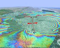
Paris, France (ESA) Oct 19, 2010 Scientists are crediting satellite imagery with helping to predict where volcanic eruptions could strike. It is well known that earthquakes can stress Earth's crust and trigger subsequent quakes, but there has been no proof of this for volcanoes until now. In September 2005, a volcanic event in Ethiopia's Afar Desert forced magma up through rocks in a crack, known as a dyke, resulting in a ... read more |
|
| The content herein, unless otherwise known to be public domain, are Copyright 1995-2010 - SpaceDaily. AFP and UPI Wire Stories are copyright Agence France-Presse and United Press International. ESA Portal Reports are copyright European Space Agency. All NASA sourced material is public domain. Additional copyrights may apply in whole or part to other bona fide parties. Advertising does not imply endorsement,agreement or approval of any opinions, statements or information provided by SpaceDaily on any Web page published or hosted by SpaceDaily. Privacy Statement |


 del.icio.us
 Digg
Digg Reddit
 YahooMyWeb
 Google