 |
Greenbelt MD (NASA) May 03, 2011 Tornado tracks from last week's powerful tornado outbreak are visible in data from NASA's Aqua satellite and the Landsat satellite. Among the more than 150 tornadoes reported on April 27 and 28, 2011, was a rare EF-5 storm. Such a storm has the capacity to collapse a concrete building. The tornado hit Smithville, Mississippi, where it killed at least 14 people, and moved northeast nearly 3 miles toward the Alabama border. It is the first EF5 tornado to occur in Mississippi since 1966, according to the National Weather Service. An image captured by NASA's Aqua satellite shows the path of exposed ground left in the tornado's wake. The trail left by the EF5 tornado in Mississippi is much shorter than a similar trail that cuts across northwestern Alabama. The National Weather Service rated this tornado at EF4, with winds around 175 miles per hour, said local news reports. The track was about 12 miles long, and the tornado caused more than 20 deaths. The image was taken by the Moderate Resolution Imaging Spectroradiometer (MODIS) on NASA's Aqua satellite on April 28. The image was compared to an earlier image taken on April 12, 2011 and the tracks were not present. Another satellite revealed the track from a tornado that touched down near Griffin, Georgia. In a Landsat image from April 28, 2011, a pale green swath indicated the path of a tornado outside of Griffin, Georgia. The tornado was on the ground between 12:03 and 12:28 a.m. local time on April 28, hours before the image was taken. By the time the funnel cloud lifted, the tornado had covered about 20 miles with a path about half a mile wide, said the National Weather Service. The tornado was an EF3 tornado with winds of about 140 miles per hour. The Landsat satellite image showed that the tornado moved across lightly populated farmland. Bright-colored spots that appear in the image are buildings, and some were close to storm's path. The town of Griffin is the nearest community to the storm track in this area. Landsat data was provided by the United States Geological Survey. The large storm system that generated the tornadoes was the deadliest to hit the United States since 1974.
Share This Article With Planet Earth
Related Links - Earth Observation News - Suppiliers, Technology and Application
 NASA Mission Seeks to Uncover a Rainfall Mystery
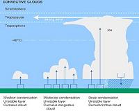
Washington DC (SPX) Apr 29, 2011 Scientists from NASA and other organizations are on a mission to unlock the mysteries of why certain clouds produce copious amounts of rain. In a field mission that is now under way, aircraft are carrying instruments above and into rain clouds. Meanwhile scientists are also getting rainfall measurements on the ground. This field campaign provides the most comprehensive observations of rain ... read more |
|
| The content herein, unless otherwise known to be public domain, are Copyright 1995-2010 - SpaceDaily. AFP and UPI Wire Stories are copyright Agence France-Presse and United Press International. ESA Portal Reports are copyright European Space Agency. All NASA sourced material is public domain. Additional copyrights may apply in whole or part to other bona fide parties. Advertising does not imply endorsement,agreement or approval of any opinions, statements or information provided by SpaceDaily on any Web page published or hosted by SpaceDaily. Privacy Statement |


 del.icio.us
 Digg
Digg Reddit
 YahooMyWeb
 Google